Researchers develop new technique to analyse rivers
Habitat alteration from climate change will be easier to detect thanks to a new approach using satellite imagery in analysing a network of waterways known as braided rivers.
A new study led by researchers from Queen Mary’s School of Geography has provided a fresh approach to understanding the structure and kinematics of braided river networks.
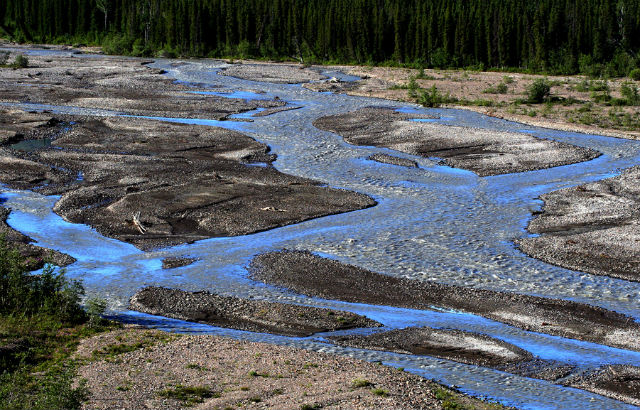
Braided rivers are one of the most dynamic natural landforms that shape the surface of the planet. They comprise multiple active channels that split apart and then come together, separating and enclosing areas of exposed sediment and vegetated islands. This network of channels adjusts continuously, driven by high rates of erosion, transport and deposition of sediment.
Satellite-based observation data and graph theory
The recent revolution in the availability of satellite-based earth observation data provides important opportunities for new insights into braided river behaviour at multiple scales and through time. However, in order to take advantage of these developments, new tools for analysis were required.
The study examined the potential to use graph theory (the mathematics of networks) to explore the structure of braided river networks, overcoming some of the shortcomings of traditional approaches.
The research, which crosses multiple disciplines, also uncovered striking similarities between the structure of these natural river networks and other diverse systems such as roads, communication technologies and even the brain.
New insights
Gabriel Connor-Streich, lead author of the paper, said: "We are just lifting the lid on network-based approaches to understanding braided river behaviour at an exciting time in which the concept of connectivity is coming to the fore within geography and environmental science. This has been made possible by the recent upsurge in the availability of satellite earth observation data.
"These data give us not only the spatial, but also now the temporal coverage to analyse the dynamics of braided rivers, which are systems that can threaten infrastructure and agriculture, but also support distinctive and rare ecological communities.
"We hope that by combining satellite-based observation with the tools afforded by graph theory, we can develop new insights into these ever-changing earth surface features."
Further information
This study was published in July 2018, and was led by Queen Mary University of London in collaboration with the University of Waikato and University of Trento. It appears in WIREs Water, published by Wiley Periodicals:
Connor-Streich G, Henshaw AJ, Brasington J, Bertoldi W, Harvey GL. Let's get connected: A new graph theory-based approach and toolbox for understanding braided river morphodynamics. WIREs Water. 2018; e1296. https://doi.org/10.1002/wat2.1296
Related items

28 July 2025

17 July 2025

12 May 2025
For media information, contact: